background

Historical walks

through Puntarenas

Historical walks through Puntarenas

The areas adjacent to the port of Puntarenas are rich in historic relevance since the Spanish conquest period (1502-1563) in that they were key areas in the arrival of the conquistadors and in the founding of first settlements. In 1522, Gil Gonzalez Davila visited the Chomes indigenous settlement, in 1524, Francisco Fernandez de Cordoba founded the Villa de Bruselas in Orotina, and in 1561, Juan de Cavallon founded the Port of Landecho in the cove of Tivives.

Puntarenas is not referred to as a port until the second half of the 18th century, when the filling of the Angostura that joined the islet to the mainland absorbed the trade of the Gulf of Nicoya and took over the ancient port sites of Landecho, Caldero, Barranca and Palmar.

Without official recognition, it was a minor port and until 1772, it was used almost exclusively for trade and shipping in the Pacific. However, notably, by 1797, it already had customs offices.

In 1812, our representative in the Cadiz Courts of Spain, Father Florencio del Castillo, succeeded in, among other distinctions, enabling the Port of Puntarenas to be designated as a main port for trade in the province, according to a royal order on April 29, 1814.

The Independence in 1821 and the boom in the coffee development starting in 1830 helped consolidate Puntarenas as the most important port in the emerging Republic, since through the port the “grain of gold” was exported to Chile and Great Britain. The Pacific route allowed the small town of Puntarenas to strengthen and expand the settlement process. Its relevance was such, that in 1840, the functions of the Caldera Port were transferred to Puntarenas.

In 1840, Braulio Carrillo stimulated the settlement process of the Port and in 1845 the construction of a wood hermitage was authorized and dedicated to Saint Anthony of Padua. The emerging neighborhood was strengthened in turn with the construction of foreign and national trade houses.

Half way through the 19th Century, Robert Glasgow Dunlop, one of the foreign visitors, stated that “the Port of Puntarenas is only accessible to vessels that draw no more than 7 feet. There is no pier or dock, it is the only port of some consideration and its trade is considerably growing.” Wilhem Marr pointed out, “that in the port, the best homes are made of cedar wood and some are of two floors. Some are painted in various colors and they have a clean and decent aspect, with an assortment of shops, taverns and inns.” Meaning that, for its time, it had a commercial and urban development that would convert it into most important port of the Pacific Coast in Costa Rica.

In 1852, the Juan Rafael Mora Porras Administration decided to build a hospital with the name of San Rafael. The city title was granted on September 17, 1858 due to the increase in population and commercial activity.

Businesses were developed along the main street, extended along the statuary (today known as Avenida del Comercio), with great movement of carts from the center of the country towards the port, coastwise trade. From the center of the country, coffee and other products of the area were transported and from Puntarenas salt and Chinese rice was imported. This activity merited a lighthouse being constructed, “to avoid problems for the vessels.”

However, in 1863 Puntarenas still did not have a pier to dock the ships, nor for transportation and storage of goods. The transfer of goods from ship to port was done with boats or barges during low tide.

In 1872, the population of Puntarenas had grown and an iron pier was constructed, contracted by the businessman Adolfo Knöhr considered as the beginning of urban development in the city of Puntarenas.

In the late 19th century, businesses included goods delivery, loading and unloading, warehouses, mills, billiards, commission and loans houses, limestone quaries, carts, cantinas, hardware stores, eateries, candle, soap and soda factories, hotels, inns, jewelry stores, grocery stores, bakeries, drug stores, snack bars, shops, wineries and cattle butchering.

In 1904, the power service was installed and in 1907 the construction of the market and slaughterhouse buildings was tendered. In 1913, plumbing service was inaugurated in the city.

  • Excursion I

    1- El Cocal and Carmen Neighborhood Aqueduct Tanks

    During the Administration of Leon Cortes Castro (1936-1 940), an aqueduct was installed that brought water from a spring near Cerro San Miguel which functioned until the San Antonio de Belen aqueduct was used. During this time it was used as an additional aquifer of water supply from the El Socorro farm where today stands the El Roble High School and the Municipality has a nursery. During the administration of Jose Figueres Ferrer (1970-1974), a series of improvements were made to the aqueduct. With the approval of Acueductos y Alcantarillados (the Water Company), two large tanks were constructed in the Cocal and four more between the neighborhood of El Carmen and the center of the city. All of them were made of concrete and cylindrical in shape and 25 meters (82 feet) tall.

    Located at El Cocal. 1st Avenue 1, 15th Street.

    2- Marino del Pacifico Park

    The park was inaugurated in 2002 as a socio-environmental project that seeks to work together with the human and environmental improvement of the coastal area. Thus, its mission is to promote, support and communicate research, education and the sustainable use of the marine biodiversity. It also serves as a recreational center. It occupies the lands where the patios and the Pacific Railroad station previously stood. It is attached to the Ministry of Environment and Energy. The park has open air exhibits such as reptiles, caimans, land turtles and crocodiles. It has 22 fish tanks with some 30 native species from the Gulf of Nicoya. The aquarium has the capacity for more than one million liters (264,172 gallons) of ocean water. It has over 42,000 average annual visitors.

    Located on 4th Avenue, 10th Street.

    3- The Dock Worker Monument

    The Dock Worker Monument, El Muellero, is dedicated to those anonymous persons who day after day have put forth their best efforts to promote the port development and allow the goods arriving or departing the country to do so in the most efficient way possible. It’s a reminder of those who perform duties and manual labors and whose sweat and tirelessness erected buildings, bridges and institutions, those who since the 18th century have carried on their shoulders the national production. The monument is made of bronze and is 1.72 meters (5.64 feet) tall, work of the sculptor Brenes.

    Located on 4th Avenue, 0 Street.

    4- Pier

    The region was known as Puerto de Arenas (Port of Sand). By order of the Spanish Royal Crown, on April 29, 1814 it was officially opened as the Major Port for trade in the Province and in 1864 it became the main port of the Pacific, 8 years later (1872), the Administration of Tomas Guardia (1870-1882) constructed a pier made of iron.

    Under the Ricardo Jimenez Oreamuno (1924-1928) Administration, a larger pier was installed to facilitate the loading and unloading from the boats; it was inaugurated in 1929. Under the Jose Maria Figueres Olsen (1994-1998) Administration, the present pier was constructed, donated by the Taiwanese Government and with a cost of $15 million USD. It was inaugurated in 1998 and, between October and May, it receives thousands of visitors from the cruise liners. It receives many national and international visitors for sightseeing or fishing (corvina, sea bass, tuna, frijolillo, harvest fish).

    Located on 4th Avenue, 0 Street.

    5- Port Captaincy

    The former Port Captaincy was constructed with reinforced concrete in the early 1930s, as an inspection and control office for ships that docked at the pier. The first floor housed the offices and the second floor served as the home of the port captain.

    The property has a symmetrical layout, with a corridor and perimeter balcony with prefabricated railings; the floors have a geometrical and floral decor. A metal frame supports a covering of galvanized iron sheets and on top of this, a lighthouse can been seen. In April 2008, the Costa Rica Tourism Board re-inaugurated it as a tourism service center under the project “Puntarenas por siempre” (Punatarenas Forever). It was declared an architectural historic heritage on October 25, 1994.

    Located on 4th Avenue, 0 Street.

    6- National Technical University

    Located on 4th Avenue, 1st Street.

    The former Main South Customs, whose building-warehouse was constructed in 1938 in reinforced concrete with a metal frame and covered in galvanized iron, by the architect Jose Ma. Barrantes Monge. With an Art Deco and Art Nouveau influence which included embossed murals, decorative elements, a beautiful winding staircase and vegetable motifs.

    The Jose Figueres Ferrer (1970-1974) Administration enabled the port of Caldera and port activities in Puntarenas to come to an end, leaving the warehouse abandoned.

    During the Rodrigo Carazo Odio (1978-1982) Administration, the Colegio Universitario de Puntarenas (CUP) was established, using the former warehouse as its headquarters with majors geared towards industrial and tourism development and agricultural and ocean resources. In 1998, with the purpose of unifying the traditional technical education and the university education, six institutions of higher learning were merged with the Colegio Universitario de Puntarenas and it became the present Universidad Tecnica Nacional.

    7- The Murals

    The project was an initiative of the Costa Rica Tourism Board and the Pacific Ports Costa Rican Institute (Instituto Costarricense de Puertos del Pacifico) and developed by the Costa Rican Muralist Association, led by the artist Jean Sagot.

    The Project consists of three large murals that present different designs but maintain a thematic unity: “The rescue of the historic and architectural legacy, the biodiversity and the tourist potential of the Puntarenas province.”

    a- The first of the murals can now be seen in all its glory on the north wall of the Pacific Plaza, in front of the cruise liner pier: “Aquel verano” (That Summer), uses organic textures – vegetables and minerals - to weave the images of a surfer that defies a wave, a colorful toucan and the legendary Puntarenas Pier.

    b- The second mural: “Puntarenas: un mundo,” the piece represents a large world map whereby a strip of land stands out that symbolizes Puntarenas. The different shades of brown, cream, and yellow make reference to an old map. It is located on the side of the Universidad Tecnica Nacional Building.

    c- The south wall of the San Rafael Health Center building houses the third mural: snails, seagulls and marine turtles; the image of the Puntarenas cathedral; beach umbrellas and an appetizing Churchill drink are combined in this piece.

    8- San Rafael Health Center

    At the request of the citizens of Puntarenas the country’s president, Juan Rafael Mora, agreed to have a sanatorium built. Under the authorization of the Governor of the Region, Jose Maria Cañas, it was baptized as San Rafael; it would be the first in the province and the second in Costa Rica. The structure consists of three pavilions constructed from brick, wood, concrete and limestone. In the early 20th century, two more pavilions were added. With vast green areas and perimeter corridors. In 1940, the Social Protection Board (Junta de Proteccion Social) conceded the management of the hospital to a religious organization and today it belongs to the Costa Rican Department of Social Security (CCSS, in Spanish) which has classified it as a clinic.

    Located on 4th Avenue, 9th Street.

    9- Manuel Burgos Monument

    Known as a benefactor of Puntarenas during the first half of the 20th century, Burgos donated the property for the construction of the San Rafael Hospital and carried out intense charitable and progressive works. In 1911, he became the President of the Charity Board. There is a bronze bust in the gardens that is 60 centimeters (2 feet) tall and was erected in the Public Works Workshops by Antonio Castiglioni.

    Located on 4th Avenue, 9th Street.

    10- Visitors’ Boulevard

    In the 1960s, Eduardo Angulo Obando proposed a project to build the “Paseo de los Turistas” (Visitors’ Boulevard) on the street which runs parallel to the beach, on 4th Avenue. Once the boulevard was established (1960 and 1970), the port became the most popular spot for vacationers from around the country.

    Thanks to the project “Puntarenas por siempre” (Puntareneas forever), substantial improvements to the boulevard have been made, with new lighting posts, green areas, the construction of public showers and reconstruction of the sidewalks and installation of benches. On April 2006, the International Symposium of Stone Sculpture and under the title, “The Magic of the Sea”, 19 limestone sculptures of 2 meters (6.5 feet) high were installed. They were designed by national artists and artists from the United States, England, Italy, Cuba and Argentina.

    11- The Esplanades (Breakwaters)

    In 1948, construction began to stop the beach erosion caused by the strong waves. However, with the passing of time and the strong tides in the area, its reparation was a priority. The project was born in 2009, with the purpose of beautifying Puntarenas and giving it breakwaters that avoided marine erosion in the area called “La Punta” (the Point).

    On November 26, 2010, authorities from the Costa Rica Tourism Board (ICT is its acronym in Spanish), and the Costa Rica Institute of Pacific Ports (INCOP is its acronym in Spanish), inaugurated the project that seems sought to beautify the public areas, stop erosion and offer services to visitors.

    Also, the project included a new entrance to the esplanades, a basketball court and beach volleyball court, a children’s play area and multi-use plazas, and seating areas for visitors.

    12- Municipal Pool

    The first community pool was built during the Oduber Quiros administration (1974-1978). However, it was closed in 2000 due to its poor condition.

    Then 12 years later, but with a new concept in services, including offering a Beach Club, it reopened its doors offering a new face to the port. The project has two pools, three restaurants, two halls for 300 people each and a parking lot for 150 cars. It also has a volleyball court and green areas. It has a capacity to house 1300 visitors and it is strategically located to have a breathtaking view of the Gulf.

    Located on Central Avenue, 37th Street.

  • Excursion II

    1- Ferry Terminal

    The Ferry Terminal has the main purpose of a maritime route that crosses the Gulf of Nicoya, with routes Puntarenas – Paquera and Puntarenas – Playa Naranjo; connecting in approximately an hour and fifteen minutes.

    Located on 3rd Avenue, 35th Street.

    2- Tourism Pier

    Built under the Oscar Arias (1986-1990) Administration, by the Costa Rica Tourism Board (ICT), it was handed over to the Municipality of the province. It is presently being managed under concession by a private company. However, since 2007, the Municipality and the ICT have joined forces to recover it and convert it into a terminal where a tour can be taken to the different Gulf islands, mainly Tortuga Island and San Lucas Island. Also, it has been given the option so that Development Associations, Chambers of Tourism and State Institutions can use its installations to carry out recreation activities for the city of Puntarenas.

    The pier consists of three boarding areas, public bathrooms, parking area and green areas.

    Located on 3rd Avenue, 27th Street.

    3- Rosalia Palacios Monument

    Rosalia Palacios was born in the second half of the 19th century in the Cauca Region in Colombia. She immigrated to Costa Rica with her family to live in the area of Puntarenas which was not much more than just a village with farms. Living next to the San Rafael Hospital gave her a sense of “love thy neighbor” and a spirit of giving as a form of human solidarity with the sick. Soon the figure of the “Negra Chalia” became known in the port and many people sought her out for advice: to assist women in labor; help underprivileged children; and give first aid to those who needed it. As a tribute to her memory a sculpture was erected at the local of the Barrio El Carmen Association of Specific Development. The monument in her honor was created in granite, sculpted by Olger Villegas.

    Located on 0 Avenue, 25th Street.

    4- “Lito” Perez Stadium

    The stadium belongs to the municipality of the City of Puntarenas and it is used by the team of the First Division (soccer), the Puntarenas Soccer Club. Its capacity is 4,105 fans.

    The stadium owes its name to the ex-soccer player, Miguel Angel “Lito” Perez Treacy. He was a Costa Rican soccer player, born in the province of Puntarenas, and whose sports career took off between 1930 and 1945. In 1974, years after his death, his friend and City Mayor, Lorgio Alvarez, proposed his name to christen the Puntarenas stadium. Now, "Lito" Perez is remembered forever in the “Pearl of the Pacific.” The stadium is commonly known as "La Olla Magica," a metaphor for the extremely hot conditions while playing on this field.

    5- Mora and Cañas Park

    It was inaugurated on December 8th, 1918. It is the largest park in the city and it has a monument in honor of the National Campaign heroes of 1856-1857, Juan Rafael Mora and Jose Maria Cañas, who were both executed on that site in September of 1860. For many years, an enormous water tank was used to supply water to Barrio El Carmen. It was designed by the architect Jose Maria Barrantes Monge, in an Art Deco style, and because of its dimensions and architectural beauty it is the most important piece of the park. This park offers playground areas as well as sports courts and spacious open areas. It was declared as an architectural and historical heritage site on April 4, 1975.

    Located on 1st Avenue, 9th Street 9.

    6- Juan Rafael Mora Porras Monument

    Juan Rafael Mora was born on February 8, 1814. He was a successful businessman involved in the coffee production area and President of the Republic from 1849 to 1859. During his legislation, Costa Rica’s independence from Spain was recognized, the Costa Rican Diocese was opened, urban growth expanded in the Metropolitan Area and the Border Treaty between Costa Rica and Nicaragua was signed. His government participated in the National Campaign of 1856 - 1857, where the people of Costa Rica wrote the most glorious page of history for defending the national sovereignty. He was overthrown from power in 1859 and executed on September 30th, 1860 in Puntarenas, after the Battle of the Angostura. A bust in his memory was sculpted in bronze by Juan Rafael Chacon.

    Located on 3rd Avenue, 9th and 11th Streets.

    7- Jose Maria Cañas Monument

    Jose Maria Cañas was born in Suchitoto, El Salvador. At a young age, Cañas showed interest in a military career and joined the army under General Francisco Morazan. He was exiled to Costa Rica after that army’s defeat. He became the Governor of the Region of Puntarenas during the Juan Rafael Mora Administration. As Governor, he supported many important projects such as the construction of the hospital and a lighthouse. He was known as one of the top military strategists during the National Campaign (1856-1857). In 1858, he was Costa Rica’s negotiator for the border treaty with the Republic of Nicaragua. In 1859, he was overthrown and executed with Juan Rafael Mora the following year. The bust in his honor was modeled of bronze by the sculptor Juan Rafael Chacon.

    Located on 3rd Avenue, 9th and 11th Streets.

    8- Municipal Palace

    The original Municipal Palace, which was of wood construction, burned down. The city hall occupied different locales until, during the government of Jose Figueres Ferrer (1970-1974), the new Municipal Palace building was constructed next to the Mora and Cañas Park. Designed by the architect Jorge Bertheau, it is a four-floor inverted cross pyramid-shape building in which on all four corners are protruding cylinder. It is the tallest building in the city.

    Located on 3rd Avenue, 9th Street.

    9- Jose Marti High School

    In the absence of a secondary school, the lifeblood of the city demanded that the government provide them with a high school. On March 23, 1942, a group of neighbors were able to establish the Delia Guevara Urbina evening high school, and in present day houses the Jose Marti High School. It occupies three quarters of a block, with a reinforced concrete core module and additions dating from 1960.

    Located on 0 Avenue, 7th Street.

    10- Jose Marti Monument

    Marti was born on January 28, 1853 in Havana, Cuba. At 16, he published his first political writings, which led to the confrontation and persecution of the Spanish colonial power. In 1871, he was deported to Cadiz, Spain. In Spain, he published his book, “Presidio politico en Cuba” (Political Prisoners in Cuba) and he graduated as a lawyer. He lived some years in Spain and in France, and later he decided to relocate to Veracruz, Mexico to work as a journalist. In 1878, he returned to Cuba, but was again deported to Spain. From 1880 to 1890, he travelled throughout Latin America working as a press correspondent and crafting influential literary and polical writings. On April 11, 1895, he disembarked in Playitas, in a pro-independence revolutionary uprising. He was fatally injured in the Battle of Dos Rios. Considered as the Apostle of the Independence of Cuba, his bust is made of bronze and the author is unknown. It is found in the Jose Marti High School, melted in the Cuba’s Civil Military Workshop in 1956.

    11- Cathedral

    Toward mid-19th century, the construction of a chapel was authorized by the patronage of Saint Antony of Padua. In 1850, the parish was completed and in 1858, the modest wooden chapel was erected. In 1889, the Sacred Heart became the new patron of the community. With the coming of the 20th century, a fire consumed the church. Between 1902 and 1905, and under Father Esteban Vasquez’s leadership, a new church was constructed. The designer was the engineer Luis Matamoros Sandoval. Cut rocks from Esparza and Barranca were used, which were carved by stonemasons from Cartago. The church has three naves, two crosses, an apse that tops the headpiece of the property, lancet windows and small buttresses on the side walls. The central tower is equipped with four clocks. Initially, the floors were made of brick, bought from the Humberto Canessa Factory, but now visitors see floors of terrazzo. Its exterior construction is influenced by late-French romantic architecture; meanwhile in the interior the design suggests neoclassical historicism architecture featuring Doric columns. The Cathedral was constructed facing the east, to face the townspeople. It was declared an architectural and historical heritage site on May 17, 2002.

    Located on 0 Avenue, 7th Street.

    12- Culture Center

    It is divided into two construction modules. The oldest one was built during the late years of the 19th century, which is the “Comandancia de Plaza” (Police Headquarters) and the jail section was built in 1913.

    It was conceived as a military barracks with battlements and towers. The Command headquarters of the Plaza had an area for the soldiers’ rooms and a main yard. The jail had a series of cells for the prisoners. It was designed in a neo-colonial influence with slightly pointed arched windows. In 1977, the building was turned over to the Ministry of Culture, Youth and Sports with the objective of turning it into a cultural complex. At the beginning of the 1990s, under the responsibility of the architect Leonardo Silva it was converted to a historical sea museum, offices, temporary exhibition hall and an auditorium. The jail section was taken over by the architect Rodolfo Sancho Rojas and it became the Public Library of Puntarenas. It was declared an architectural and historical heritage site on May 16, 1989.

    Located on 0 Avenue, 3rd Street.

    13- Victory Park

    Its name corresponds to the tribute that the city of Puntarenas offered to the Costa Rican Army that fought during the National Campaign of 1856-1857. The city of Puntarenas and its port were vital for the passage of our military troops to Nicaragua and it was also the military base of our Navy fleet. The troops celebrated the victory in this space. The park provides big open areas populated with shady trees and has a rectangular figure of about 100 meters (328 feet) long and 20 meters (66 feet) wide, according to the design of the architect Hernan Gutierrez Brown. The Park has a kiosk made of reinforced concrete and a roundabout on the north side along the estuary.

    Located on 1st Avenue, 3rd Street.
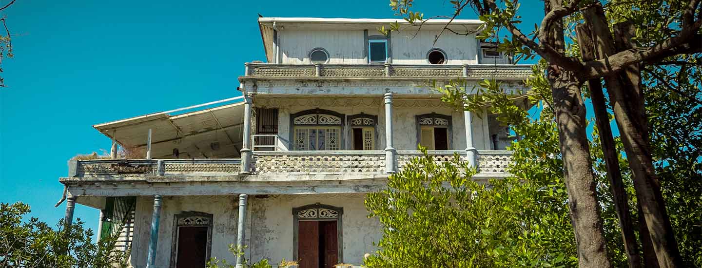
    14- Fait House

    The house was constructed between 1924 and 1925 by Alberto Fait Rocchi, an Italian immigrant who lived in Costa Rica in 1887 and who was contracted by the government as mechanic to repair ship boilers. The two- floor house is built with reinforced concrete with Victorian style influence with a space destined for internal ventilation, where ornamentation work with geometrical and vegetable Art Nouveau inspirations can be appreciated. Also, on the second floor, wrought iron railings can be found. On the roof, galvanized iron sheets form five monitors that facilitate the ventilation of the ceiling. Fait had to return to Italy due to health reasons, leaving various projects pending and as a consequence to his return, the Banco de Costa Rica seized the house. The property was auctioned off and bought by Miguel Macaya Lahmann, which was then passed on to Emilio Helpennstell and today it belongs to Elizabeth Magne. It was declared an architectural and historical heritage site on March 5th, 2003.

    Located on 3rd Avenue, 3rd Street.

    15- Local Market

    The market began to operate under the shade of the trees towards, the estuary, where people would meet to sell their wares. Later, simple wood stands were built, concentrated on the street which extended along the estuary, becoming the “Calle del Comercio”.
    In 1907, Enrique McAdam was responsible for the construction of the marketplace. The facades were built in adobe. The marketplace occupies a city block. It began with 86 stands and today there are 63 working stands. There are vegetables, fruits and medicinal plant stands, as well as fish markets, butcher shops, stores and cafeterias. The market opens its doors every day from 6 a.m. to 4 p.m. It closes only on Holy Thursday and Good Friday of the Holy Week and December 25 and January 1.

    Located on 3rd Avenue, 2nd Street.


Planning your Trip to Costa Rica


#EssentialCostaRica

Share your experience