Tourist attractions
in Puntarenas
Tourist attractions in Puntarenas
-
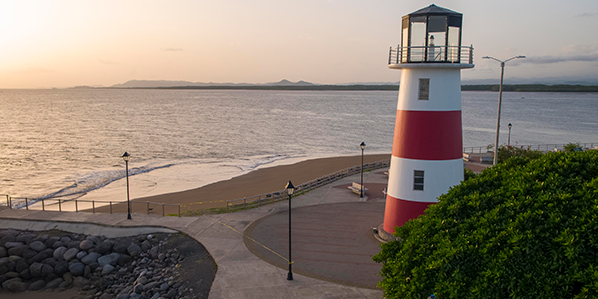
Paseo De Los Turistas (Visitors Walk)
This stretch is located along the main beach in Puntarenas and is one of the most heavily visited. Around the pier where the cruise ships dock, there are many kiosks where local arts and crafts as well as traditional fruit salad and frozen drinks called Churchill’s can be enjoyed. Along this stretch, there are other services provided for tourists, including sport fields, park areas, showers, restrooms, and everything else needed to enjoy the beach.
-
Marino Del Pacifico Park
This park was established in 2002 and is located at the historic train station. Its main attraction are the fish aquarium holding species native to the Pacific Ocean, as well Cocos Island. There is also a restaurant and a souvenir shop. It is open to the public from 9 a.m. to 5 p.m.
-
Historic Marine Museum
This museum is located in the historic Puntarenas barracks, which was restored in order to accommodate the Culture Museum, an amphitheater, and a public library. The first of these is used to exhibit monthly paintings and sculptures. The amphitheater has theater, dance and music performances. The historic information centers on the city of Puntarenas and shows how the port became one of the most important in the country, while preserving the religious traditions and celebrations of Puntarenas is known for. The museum also shows the diversity of natural resources in the area, such as wetlands, forests, marine areas, land animals, and birds. Museum hours are Tuesday to Sunday from 9:45 a.m. to 5:15 p.m. In the same area are the Sacred Heart of Jesus and the Puntarenas Cathedral, which was built in 1902.
-
“Pura Vida” Garden And Waterfalls
This extremely beautiful waterfall is one of the highest in the country, reaching some 650 ft. There are also colorful gardens, trails, and pools for swimming in this area.
-
Venado Island
This island covers 968 acres and stands out among the other islands in the Nicoya Gulf because of its green ocean water. The inhabitants of the islands are farmers and fishermen. There are an abundance of marine birds that nest on the island or in the mangroves around the Jicaral estuary.
-
Pan De Azucar Island
This little island is located south east of the San Lucas Island. Its scenery is beautiful and the island is home to a large population of marine birds, particularly brown pelicans.
-
Muertos Island (Gitana)
Many years ago, there was a cemetery here, hence the name (“the dead” in English). It is also known as Gitana. The majority of its small land mass (some 60 acres) is covered by dry tropical forest, which is transitioning to a wet forest. Many marine birds come to the area and the surrounding scenery is lovely.
-
Jesusita Island
This island is located northeast of Cedros Island, which is very close by. Its 60 some acre land mass is made up of dry tropical forest, which is transitioning to a wet forest. Northeast of the island is a rocky coast and a beautiful beach. There is also another beach in the southern part.
-
Chira Island
This is the biggest and most populated island in the Nicoya Gulf (25 sq. miles). It also offers the largest number of services, including elementary schools and a high school. There is a big mangrove on the northeast side of the island. There is an eco-tourism area run by women from the island. Here they offer basic lodging, food and tours for fishing and exploring the mangrove.
-
Cedros Island
This island covers fewer than 400 acres and has a very beautiful landscape due to its irregular shoreline. There are two main beaches: Langosta and Gringo. There are forests with small trees, coconut trees, and plants. There are organized tours to this island.
-
Caballo Island
This long island is less than 2 sq. miles. The Peter Harley Canal separates the Bejuco Island from this small isolated land mass, which is rich in trees and is surrounded by coral reefs and cliffs. Toward the center are the highest elevations of the island, which measure less than 650 ft. above sea level.
-
Bejuco Island
This island measures less land mass than Caballo Island, but is similar in its long shape and has a maximum elevation of 400 ft. above sea level. There is an irregular surface with an abundance of tree species.
-
Virgen Del Mar Festival
Every 16th of July, colorfully decorated boats are created to remember a famous event that occurred many years ago. As the story goes, a group of fisherman who were shipwrecked and nearly dead, were rescued shortly after calling on the Virgin Mary for help. During the festival, people participate in many different kinds of water sport competitions and other recreational activities for children and adults. It is also celebrated in Quepos.
-
Puntarenas Estuary
This estuary is located in the Nicoya Gulf and covers some 5 miles. Its irregular shoreline is home to beautiful mangroves where many types of birds come to nest. This mangrove is part of the Wildlife Refuge. Throughout the estuary, due to its calm waters, there are all kinds of fishing boats, sail boats, and tour yachts, which give the maritime area a special appeal. It is also a good area for water skiing.
-
Mata Limon Estuary
The waters here are used for jet skiing and water skiing. There are also some good areas for fishing. The Puerto de Caldera is nearby.
-
Jesus Maria Estuary
This estuary is good for fishing and has a variety of flora and fauna. There are also many colorful birds that are easy to see.
-
Town Of Cobano
Cobano, located 518 ft. above sea level, has many commercial services and tourist-friendly businesses offering lodging, food, and tours and more. It is a starting point for many interesting tourist attractions like Montezuma, Cabo Blanco Reserve and Malpais.
-
Orotina
Orotina is a well laid out city with parks, a church, and a local market, where they sell local food and drinks. It is 751 ft. above sea level and a hot dry climate, which makes it ideal for fruit production.
-
Esparza
Esparza is a historic city that was sacked in past centuries by English pirates. It is the oldest city in the country that has never changed locations. There are many historic buildings located here, including the Esparza Church and the Torres Elementary School. There are many services provided for visitors and the local dishes make it a “must stop” destination.
-
Puntarenas
The city or port of Puntarenas is about 13 ft. above sea level with many wide open beaches for enjoying the sun and the ocean. Historically, it has been a recreation spot for national tourists. It provides many high quality tourism services that bring in international tourists. There is a ferry service to nearby destinations like Paquera and Cobano, as well as islands and mangroves located in the Puntarenas Estuary. Land transportation services to Miramar and neighboring communities of Montes de Oro and Santa Elena de Monteverde depart from here. Puntarenas has rest stop areas with local dishes and drink offerings. Much of the local cuisine comes from the ocean like the popular local ceviche in restaurants and hotels. There are other buildings of interest and historical sites.
-
Miramar and Montes De Oro
Miramar is a historical city known mainly for its gold mining. Nowadays, the city residents are primarily employed in farming and tourism.
-
Montezuma Waterfall
A 20 minute walk from the city, the waterfall is some 65 ft. high and has a refreshing pool surrounded by lush vegetation.
-
Cocalito Waterfall
This refreshing waterfall is located on the far northeast end of Cocalito Beach. It is 40 ft. high with a pool at the bottom for swimming and taking in the surrounding beauty of the lush vegetation and deep-blue ocean. This is a very scenic and relaxing place.
-
Puntarenas Festivals
Parades, concerts on the beach, and many other recreational activities create the perfect environment to join in and share the culture of the people from Puntarenas. These festivals are scheduled during February, when the weather is dry and ideal for enjoying the beach and all the events scheduled during those days.
-
Barranca River Mouth
This place is popular among surfers for its long left bending waves. It is also a great place for hiking and observing the ocean view.
-
Tarcoles River
This river is 387 ft. long and on its lower riverbed, particularly around the coastal highway, there are crocodiles. There are tours that go along the river to observe these large reptiles.
-
Tivives Beach
This beach is located some 5 miles past Puerto Caldera, along the unpaved road. There are strong waves here making it popular among surf enthusiasts. There is a large mangrove and its long beach is ideal for walking, horseback riding and sunbathing.
-
Tambor Beach
This beach is located in Ballena Bay, with Pochote Beach at the far northeast end. It is a very beautiful and long beach great for swimming, hiking, horseback riding and water sports. The bay has a special feature resembling the profiles of two lizards. The area also possesses coastal vegetation and many types of services, from cheap lodging areas to all-inclusive luxury hotels. There are also many available activities including golf, sportfishing, diving tours, water sports, horseback riding, mountain biking and more.
-
Quizales Beach
This is a very beautiful scenic beach and to the far north is a cliff which offers a great view of the coastline.
-
Puntarenas Beaches
These beaches extend all along the coast in Puntarenas, from the mouth of the Barranca River to the area known as La Punta, where the stretch ends. The Tourist Walk has a number of hotels, restaurants, bars, and other services, including boat rides.
-
Cocal, Cocalito And Quizales Beaches
These beaches are located in a very scenic part of the coastal area, with sandy beaches and rocky cliffs surrounded by lush tropical vegetation. Cocal Beach is wide open and suitable for swimming, sunbathing, hiking, and horseback riding.
-
Caldera and Mata De Limon Beaches
This beach extends from the Mata de Limon Estuary to the hill known as Roca Carballo. It is very popular, as is the Puerto de Caldera, where large ships dock. The estuary can be traveled by boat to better enjoy the flora and the fauna of the mangrove.
-
Santa Teresa Beach
This beach is very long with favorable waves for surfing and full of coastal vegetation. There are beautiful rock formations on the north end known as Peñon de Ario. From Santa Teresa Beach looking south, the Cabo Blanco Absolute Nature Reserve is visible. Besides sunbathing and swimming, the beach is also good for hiking, horseback riding, mountain biking and camping.
-
Pogeres Beach
This beach is a small and beautiful inlet and is great for swimming and taking in the surrounding maritime scenery. Many fishing boats anchor here.
-
Pochote Beach
South of Manzanillo is Punta Ponchete, which is a rocky little inlet with lush vegetation and great scenic views. It is great for hiking, enjoying the ocean, sunbathing, and other activities.
-
Organos Beach
This beach is located some 2 miles from Paquera. It is a little less than one mile long and has an estuary (Oganos) and a mangrove on the northern end. It is very popular among locals from the surrounding areas. It has beautiful scenery and from its shoreline the Negritos and Tortugas Islands are seen.
-
Naranjo Beach
This long beach is ideal for hiking and taking in the magnificent panorama that includes La Peña de la Bruja (Witch’s Rock) – a little rocky island that is popular among surfers. Camping is also permitted on this beach.
-
Montezuma Beach
This very beautiful coast is made up of a mix of rocky areas and white sand beaches. There is an abundance of vegetation that is home to numerous howler monkeys and birds. The center beach of Montezuma is a small beautiful inlet. North of this area is the main beach, which runs a few hundred feet toward the rocky area, where a path begins that connects to other beaches like Cocal.
-
Malpais Beach
This beach has a very irregular rocky shoreline. There are areas of great natural beauty due to the fact that not only is there coastal vegetation along the shore, but there are also nearby forest areas. In the central part of the beach is La Punta Barrigona, which is a good place for hiking and taking in the surrounding ocean view. On the far southern end of Malpais is La Punta Cuevas, an equally beautiful area that is part of the Cabo Blanco Absolute Nature Reserve. Surfing, horseback riding, diving, sportfishing, mountain biking, and kayaking are all very popular activities at this beach.
-
Gigante Beach
This is a small beach surrounded by mountainous hillsides with lush vegetation. The waves are small and from its shoreline looking south, visitors can see La Isla Muertos a short distance away. Perfect for relaxing, hiking or horseback riding, Gigante Beach is worth seeing.
-
Doña Ana Beaches
This beach, as well as the nearby mouth of the Barranca River is very popular for surfing. Doña Ana, because of its size, vegetation, views, and tourism facilities, is a great place to enjoy the ocean. This beach has been awarded the Ecological Blue Flag, meaning it has been recognized for its cleanliness and safety.
-
Curu Beach
Located in the Curu Natural Wildlife Refuge is a small inlet with small waves. It has coastline vegetation, a mangrove, and various forests teeming with howler and white-faced monkeys, raccoons, iguanas, and many other animals. The coastal landscape is very beautiful and is a great place for swimming, observing the flora and the fauna and relaxing.
-
Carmen Beach
This beach is located between Santa Teresa and Malpais. Besides enjoying the sun and the beach, this shoreline is good for hiking and horseback riding, as well as mountain bike riding and sightseeing. It is also popular among surfers.
-
Cabuya Beach
This is a rocky beach with a wide open ocean with an abundance of coastline vegetation and strong waves. It has a beautiful coastline, highlighted by the Cabuya Island, which is a pre-Columbian indigenous cemetery that visitors can walk to during low tide. This beach is ideal for hiking and observing nature especially at Cabo Blanco.
-
Blanca Beach
This beach is located in the Murcielago area of the Santa Rosa National Park. It is located in the Santa Elena Peninsula, the oldest historical geological area in Costa Rica. It is a beautiful bay with an abundance of coastal vegetation and is ideal for relaxing, hiking, swimming, and observing the interesting flora and birdlife. There are other nearby beaches like the Santa Elena Bays and El Hachel.
-
Agujas Beach
This is a beautiful and protected little inlet with a variety of coastline vegetation. It is good for swimming, relaxing, and watching the ocean.